History of Clacheranmor in Maps
- John Burkinshaw
- Mar 7
- 3 min read
Before my house was built in 1980 there was a small cottage, known as a but and ben, on the site called Clacheranmor Cottage.
The phrase but and ben is steeped in Scottish history and culture, traditionally crofting but also rural life generally. It can evoke a poverty-stricken hardscrabble life that has at times been romanticised, as in this song by Sir Harry Lauder:
Just a wee deoch an’ doris, afore ye gang awa’;
There’s a wee wifie waitin’ in a wee but an’ ben.
(Deoch a doris, a custom of a parting drink, is from Scottish Gaelic deoch an doruis, a drink at the door.)
A but and ben is a two-roomed house of one storey. There was usually only one door to the outside; this gave access to the kitchen, the public room in which everyday life took place and in which members of the family often slept. This led into a private inner room, where guests could be entertained and which - like many a front room or best room in poor but decent homes everywhere - was often furnished to a higher standard but less often used. If the family was large, however, the inner room could double up as a bedroom. The outer room was the but and the inner one the ben. Putting them together the but and ben was the whole house. It would have looked something like the below.

Clacheranmor Cottage but and ben obviously fell into disrepair and the current house was built by four siblings who owned next door: Achanelid farm. There are several people who still live in the glen who remember the original but and ben and the family who built my house. One lady, Barbara, who I believe is the oldest person living in the glen used to play at Clacheranmor as her uncle owned the house when it was first built. Annie, from Glendaruel Caravan Park told me about the but and ben and that the owners had planted the trees next to the house many years before the new house was built as a wind break to protect the new house they were planning.
According to Trove.scot :
ARCHAEOLOGY NOTES
Category: Descriptive accounts
Event reference: 776111
NS08NW 22 0050 8789 Clacheramor cottage which is depicted as roofed on the 1st edition of the OS 6-inch map (Argyllshire 1869, sheet clxii) is shown, roofless, on the current edition of the OS 1:10000 map (1979)
Information from RCAHMS (PM) 30 April 1998
Sadly on National Library of Scotland the sections of the map showing Glendaruel are mysteriously missing from the OS 1:10000 map (1979). But I did find all the below maps showing the evolution of the land around Clacheranmor over the years. Each map has a date on it.
Below are two maps from 1888-1915 compared with satelite views from recent years - one showing the whole glen and one zoomed in on my house. You can see minor variations in the shape of the river and the fact that the square patch of woodland next to the house hasn't been planted yet on the old map. Clacheranmor Cottage was a lot smaller than the existing house.


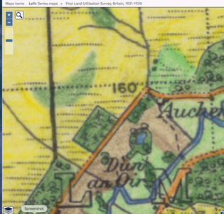
On the maps below you can see top left is 1830s-1880s with Clacheranmor Cottage clearly marked. Achanelid farm house is shown on the next map (top right) which was 1856-1891. It also shows Dun an Oir, which is a mausoleum to the Campbell Clan slightly down the glen from my house, but perhaps slightly incorrectly placed too far to the north. The addition of contour lines shows the steep hill behind my house. Bottom left, the map is 1892-1949. I included this one as I found the different spelling of Achanelid interesting. The last map at bottom right is dated 1931-1938 shows a small pond below the motte, which is no longer there.


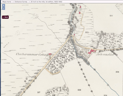
The below map (1855-1882) on the left shows buildings up the hill (at the top of the map) which I am pretty sure are no longer there. I also like the fact that it looks like there is a tree lined driveway up to Clacheranmor Cottage, which would be quite a feat as the spot where the building is is about ten feet higher than the road, and there is a burn that runs alongside the road which would have needed to be bridged, but that doesn't show on the map. The righthand map is 1892-1960. On this one Dun an Oir, the motte, is more correctly labelled further down the glen from the above maps. At the bottom of the map is Glendaruel house, which also no longer exists. See future blog about places of interest in the glen!


Comments